Moving Spatial Data into Augmented Reality


I recently had the opportunity to attend AR Dev Camp Vancouver, an un-conference focusing on Augmented Reality (AR). This is an emerging field that involves changing what you can see by overlaying information on top of a camera view, like in the movie “Terminator”. So, what does this mean for geospatial professionals?
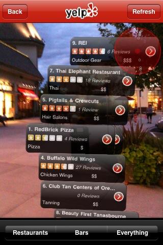
First a bit of recent history. AR has been getting very popular lately, thanks to new devices, such as the iPhone and several Android-powered phones that combine a compass, a GPS, and a camera (as well as a nearly-persistent network connection to fetch data) in a single pocketable device. The current craze started when the business review service Yelp included an easter egg in their iPhone app that overlaid nearby businesses on a camera view.
As AR involves adding things on top of real world objects, it often requires spatial data. This spatial data can be combined with a compass, a GPS, and a camera to intelligently guess what you are looking at and overlay this data on top of the view. Just about any point data can be displayed in an AR environment, as long as the data is in a format that the environment understands.
To accomplish the AR effect, all that is needed is 3D point data (something that many of you probably already have) and an application that can consume it. There is a push to make ARML the standard format for this data. This is good news for geospatial professionals, as it is nothing more that KML with some optional added metadata for styling.
There is even a case where someone used FME Server to create a layer for the Layar iPhone and Android app. Layar has a service that can turn JSON into AR in their app, so it was just a matter of Vicrea, transforming some existing data into structured JSON that could be streamed into Layar’s API. In Vicrea’s case, they took POIs from the city of Münster and created a layer for them so that a user could point their phone at a pub (or anything else in the database) and get more information about it right on their smartphone’s screen.
The AR Dev Camp was a great opportunity to talk with people in this space and get an overview of where AR is heading. It looks like geospatial professionals are in a good place to easily create services that can stream data from their existing databases into AR environments. So go ahead and add your own data to Layar or another AR environment and give your users another way to view the data.


