
How to Migrate your Google Maps Engine Data

Following Google’s recent announcement that they’re discontinuing support for Maps Engine, you’re likely in the middle of deciding where to move your GME data. If you still have no idea where to go, check out my last blog post on 6 alternative systems worth considering.
You have exactly one year before your GME data disappears from Google’s servers. Fortunately, you can extract it instantly. FME, widely trusted in data migration, is one of Google’s recommended solutions for exiting Maps Engine gracefully. Let’s look at how to use FME to take full control of your data, first loading it into whatever destination system you’ve chosen, and then setting yourself up for future data success.
1. Move your GME data into your alternative system
Extract all or some of your data from GME and load it into your destination system of choice. With FME, this is the easiest-peasiest thing you can do. It’s what it was made for. This is like asking an astronaut to visit the ISS. Like asking a firefighter to extinguish a flame. Like asking a comedian to tell a joke. Like asking a Disney villain to cackle evilly. You get my point.
In FME Desktop, this means dropping a GME Reader onto the workspace canvas, then a Writer in the format of your choice, then connecting them.
If you want to see an example in action, I’ve made two quick demo videos:
How to migrate Google Maps Engine data to ArcGIS Online
See also How to migrate Google Maps Engine data to CartoDB. Replace the output format with your system of choice, and you can see how simple it is.
2. Transform the data
If asking FME to do a format-to-format conversion is like asking an astronaut to visit the ISS, then applying a transformation is like asking him to do a bit of science while he’s there. (Sorry, I’m in the middle of An Astronaut’s Guide to Life on Earth right now—can you tell?) Anyway, transforming data along the way lets us get the most out of our data excursions.
Modify the schema
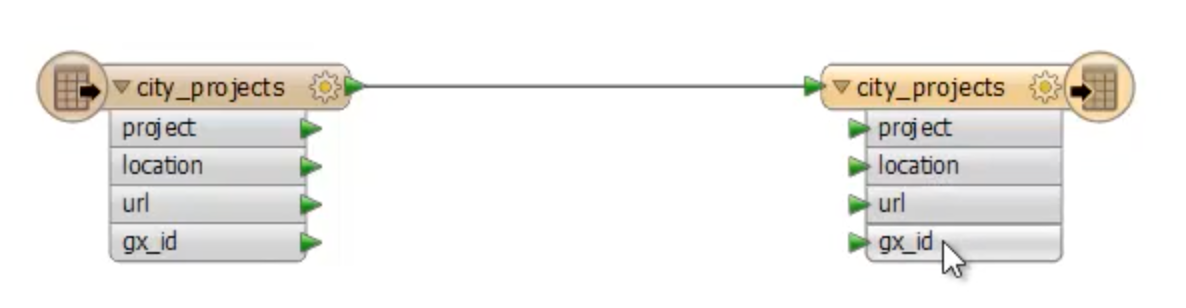
Before loading your data into the destination system, you can modify its schema (i.e. the table names and columns, layers, categories, attributes, allowed geometries, anatomy, physique, whatever terms you use to define the structure of your data). In the Google Maps Engine world, the schema modification you’ll most likely be concerned with is that little gx_id attribute.
When you first put your data into Google Maps Engine, the system appended a gx_id column to your table, which is simply a field containing a primary key. You don’t need this in your destination system. Get rid of it like so:
http://vine.co/v/OTFemi30PaA
Validate the data
Do you make a habit of checking the quality of your data? If not, you shouldn’t admit that aloud. Data validation is critical. Here’s a data quality checklist:
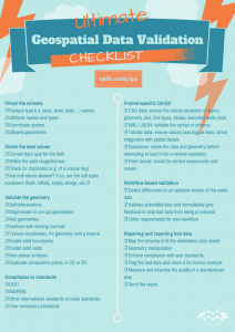
Before loading your data into its new system, make sure it’s robust. FME has loads of transformers to help you fix bad data.
Validate. You’ll thank yourself later.
Other transformations
FME offers hundreds of transformers to help you get your data exactly as you need it. Here are a few examples:
- Use the Tester to filter some records into destination table A and others into table B.
- Use the Reprojector to change the data’s coordinate system.
- Use the RasterTiler to split your GME Rasters into smaller ones of a specific size, to meet any limitations in your destination system. (See other ways to work with rasters.)
- Leverage ArcGIS Online services like geocoding, geoenrichment, routing, and drive-time polygons. (If your destination system is ArcGIS Online, make sure you check out this infographic to see everything you can do with your data once it’s there.)
- Copy, create, classify, or otherwise dynamically change the attributes.
- Merge seamlessly with other data, like CAD, GIS, BIM, raster, database, web, point cloud …
The possibilities! They’re endless!

3. Beyond one-time translations: automation and more
FME is more than a desktop environment. FME Server opens up a world of automation potential. For example, set up a schedule to automatically continue moving your data between whatever systems you choose. Set up notifications to email yourself once a migration is complete. Trigger another FME workspace to continue the transformations.
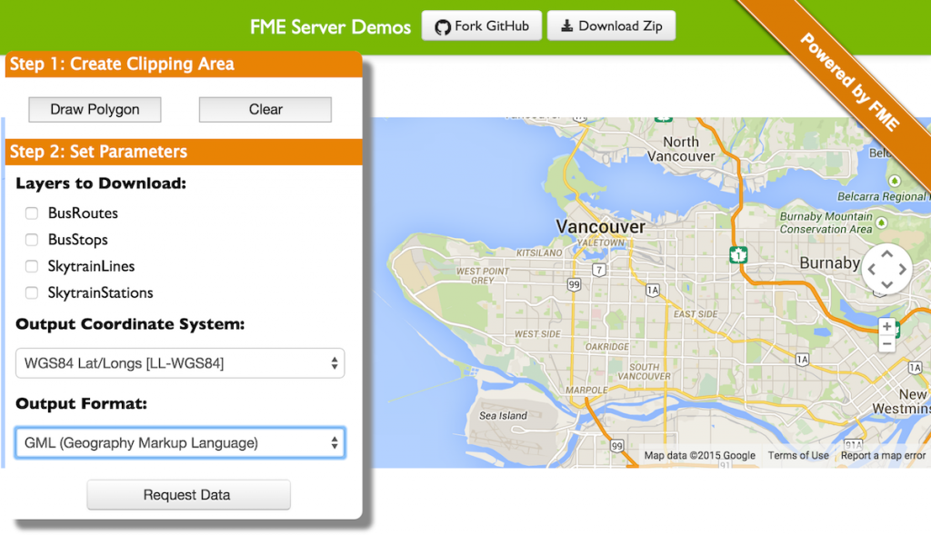
You could even offload the migration task to your end users by creating a self-serve GME access portal. They don’t even need to know how to use FME. To them it’ll look like this:
Our goal at Safe Software is to help you get your data where it needs to go, quickly and painlessly. Your data should never be stuck inside any specific system. It should be free, fluid, ready to be leveraged in whatever way you need it. So wherever you choose to move your Google Maps Engine data, we want you to find the move trivial, as though it was meant to fit in that system all along.
What do you plan on using instead of Google Maps Engine? Do you have an exit strategy in place?
Explore more blog content headline

Data-Driven Marine Operations: 5 Ways to Generate Actionable Insights from Ship to Shore

Introducing FME Form 24.0: Redesigned User Experience for Focus and Consistency


[New!] AI Assist in FME: How to Build Better Data Integration Workflows with the Help of AI