Today we welcome a guest post by William Tober, one of the GIS and CAD experts at MNC. MNC needed to make an automated validation process for incoming files to ensure they comply with a range of business rules. Using FME, they developed online digital data submission solutions for 3 Canadian provinces. Here’s a look at the top transformers they use for data validation.
| Martin Newby Consulting Ltd. (MNC) is a geomatics engineering firm founded in 1997 in Calgary, AB. Our highly specialized team of GIS experts, solution engineers, analysts, programmers, mapping and surveying technologists and geomatics engineers are digital data experts, especially with CAD and GIS data formats. |
Many businesses today manage large quantities of incoming digital data (either internally or externally generated). FME Server provides streamlined ways to automate the validation of incoming CAD or other digital data files that must adhere to certain business rules.
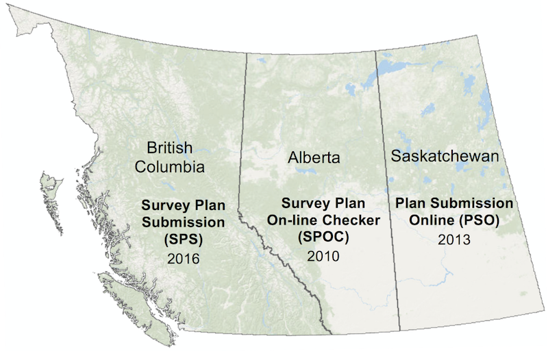
For example, survey plans must meet specific criteria before they can be submitted to government agencies. MNC was instrumental in the development of online digital data submission solutions for survey plans registered in Alberta, Saskatchewan and British Columbia using FME Server.
The wide range of business rules verified have shown that FME Server’s digital data checking capabilities can be extended beyond validating survey plans to checking any form of incoming digital data (e.g. engineering/architectural CAD drawings, TIFFs, PDFs, spreadsheets).
FME’s readers, writers and transformers allow for many different types of quality conditions to be checked. Here are examples of some business rule specifications for survey plans in Saskatchewan that were automatically checked through the Plan Submission Online (PSO) program:
Examples of PSO Business Rules Checked with FME
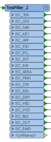
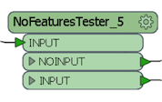
Does the Layer structure adhere to the requirement?
A TestFilter transformer was used followed by a NoFeaturesTester custom transformer to test for the presence of features on specific required layers in DWG format.
Does the drawing scale match the specification?
The StringSearcher transformer combined with regular expressions can be used to robustly pick out the scale from the survey plan title block text.
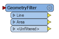
Is the Area of Interest outline that defines the extent of the survey present?
This CAD entity represents the extent of the survey or area of the plan to register and may be either line or area. Checking for the existence of an area of interest on a specific layer is made flexible with the help of a GeometryFilter transformer.
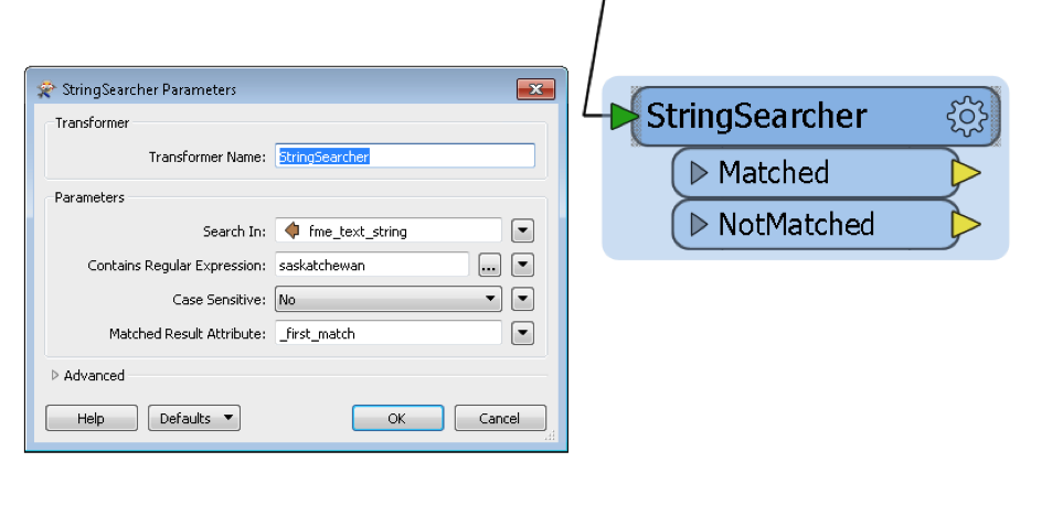
Is ‘Saskatchewan’ spelled correctly on the Plan?
Another StringSearcher transformer supports verifying this rule. Saskatchewan is either found or reported as missing/misspelled.
Does the Map border and plot size adhere to the required standard?
A unique PSO business rule is to validate that the supplied TIFF image will fit on a certain maximum paper size when plotted at 1:1. With the help of the RasterToPolygonCoercer transformer we can do the calculations on a TIFF image to calculate the plot size and map border width.
For example, with a 300 DPI image the plot size can be calculated in meters using an ExpressionEvaluator transformer as follows: PlotSize(m) = Pixels * (1in/300pixels) * (1m/39.37in)
Does the parcel line work create closed polygons without gaps or overlaps?
Using the AreaBuilder transformer survey plan parcel line work is used to build areas and any incomplete unclosed/dangling lines are output in a report.
Does the Area of the parcel polygons match the recorded area?
Using the AreaCalculator transformer the stated area of survey polygons (which are stated as text in the CAD file) can be checked against the actual area of the polygons.
Are there sufficient and correct geo-referencing points on the survey?
The CoordinateExtractor transformer is used to check that the position of the geo-reference points in the survey plan matches the coordinate locations indicated in the title block.
Benefits of Automated Digital Data Checking
Here are just a few benefits we have found:
- Reduced errors and costs
- Improved quality
- User friendly
- Visual check for users
- Automated metadata collection
- Faster approvals
- Reduced quality inspection effort for data custodians
- More secure
- More information and detail
Looking at how much we have been able to accomplish with just a few transformers, we encourage everyone to think about how FME can be used to extract, validate, and transform their organization’s digital data.
About the Author
 |
William Tober, GIS Analyst
William Tober has spent 9 years with MNC focusing on GIS and CAD data preparation and conversion. He is adept at developing processes or tools to automate workflows, provide real-time quality control, and publish or deliver datasets. He is well experienced with managing large or complex datasets within GIS projects and proficient at client support by efficiently tracking and troubleshooting problems related to data or services. 403-294-1028 | 2540 – 5th Ave NW, Calgary, AB T2N 0T5 |

Tiana Warner
Tiana is a Senior Marketing Specialist at Safe Software. Her background in computer programming and creative hobbies led her to be one of the main producers of creative content for Safe Software. Tiana spends her free time writing fantasy novels, riding her horse, and exploring nature with her rescue pup, Joey.